Itinerary of the Irminio Valley
Hiking itinerary
- Departure: Modica
- Trekking time: 6-7 h (including stops)
- Difficulty: intermediate, suitable for children and adults with trekking experiences and with a minimum of training
- Length: about 12.5 km
- Max altitude: 408 m; Minimum altitude: 130 m; Difference in altitude: 278 m
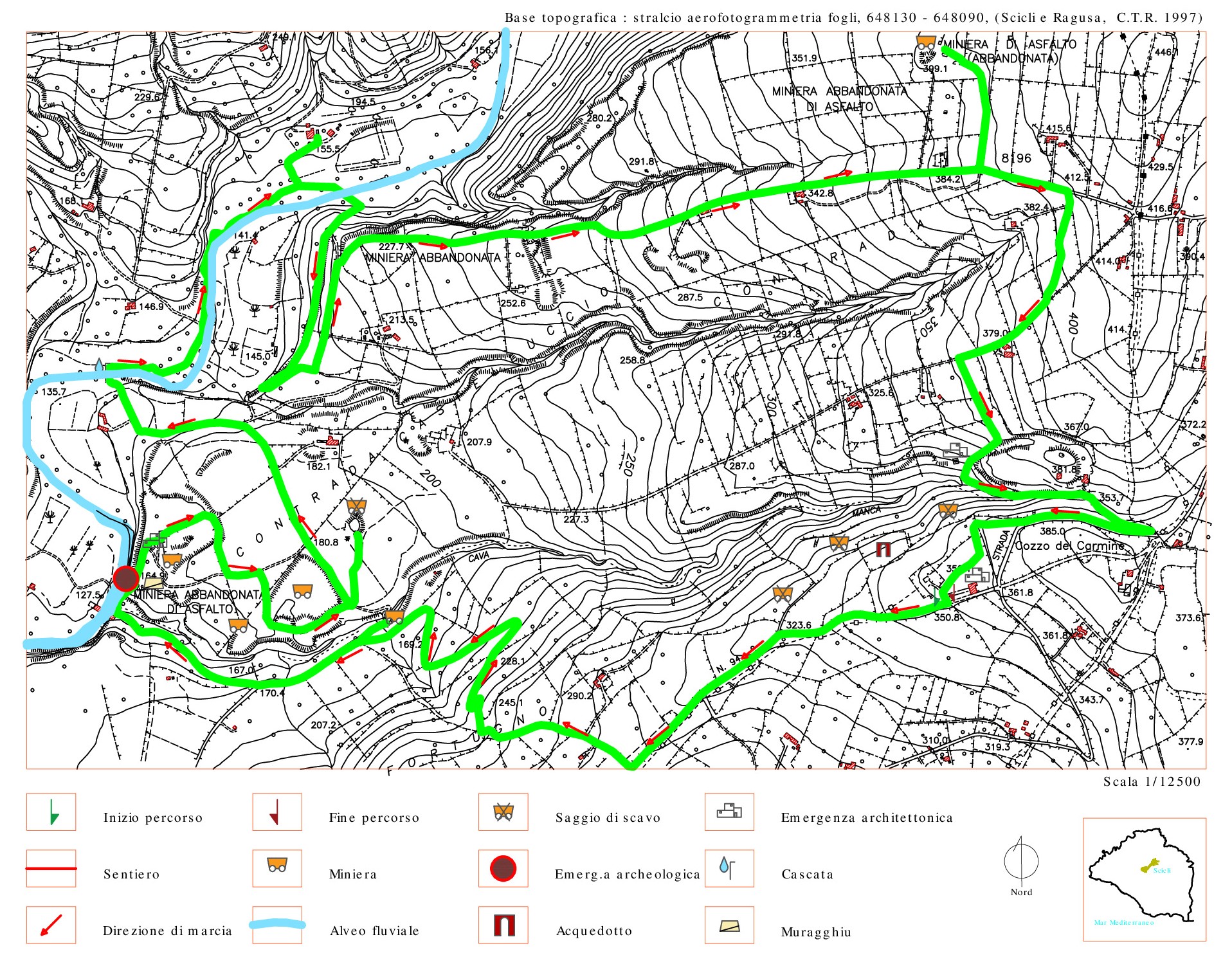
THE COURSE
The Irminio (Irminiu in Sicilian) is a river in south-eastern Sicily. It originates from Monte Lauro, the main peak of the Iblei Mountains (986 m a.s.l.) and its almost torrential path runs along the province of Ragusa for 55 kilometers. This itinerary is one of the most evocative because it allows the hiker to get to know an important part of the asphalt production industry of the past of the Iblei. The up and down path through the Irminio valley will show the tourist the industrial exploitation of the asphalt mineral deposits, cultivated both underground and in the open air between the Streppenosa and Castelluccio districts. The discovery of ancient finds testifies that the working of Ragusan asphaltic rock took place since pre-Hellenic times. Its use intensified starting from the sixteenth century for decorative purposes, especially inside churches and then, after the earthquake of 1693, for reconstruction.
The route will allow you to admire the splendid Ibleo landscape, with its intricate texture of dry stone walls, mule tracks, farms and farmhouses, exploration mining essays and some archaeological sites of great interest, immersed in the Mediterranean vegetation and typical bank of the Irminio river.
USEFUL INFORMATION AND CONTACTS
Equipment: Clothing suitable for the season: boots, jacket or windbreaker, hat, camera and binoculars.
LOGISTICS INFO OF THE ITINERARY:
- Nuccio Pisana cell.: +39 334.226 6249;
- Pietro Cavallo cell.: +39 366.132 1345
HOW TO GET:
The route develops in the territory of the Municipalities of Scicli and Modica. The starting point of the itinerary is easily reachable by taking the SP 42 from Scicli towards Modica for about 7.5 km up to the Pirato district, then turn left and take another stretch of about 650 m and turn left until you reach access to the forest area.